
May 2021 Update: the French Broad River Metropolitan Planning Organization (FBRMPO) officially adopted this plan. Here’s the official Hellbender Trail overview from the FBRMPO. AoB was part of the advisory committee that produced the plan and we are excited to see it built!
Click here for the: Map and updates from the French Broad River MPO.
The Hellbender Trail! A very important project has begun in Western North Carolina and you need to know about it so that you can support it as it evolves. There has already been an open public comment process, completed during 2020. Your feedback on the project remains important, whether directed toward the build of an underlying section, a regional politician, government employee, or a potential funding source for the project.
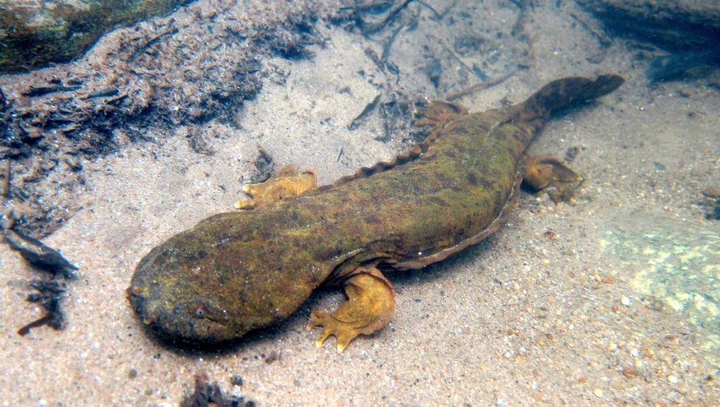
The project? A regional greenway system that will tie together many cities in Western North Carolina. The plan calls for 155 miles of greenways, shared streets, and natural surface trails. It’s called the Hellbender, named after our famous and endangered salamander.
Asheville on Bikes endorses Hellbender Regional Trail Plan
Asheville on Bikes endorses the Hellbender Regional Trail Plan that has been proposed by the The French Broad River Metropolitan Planning Organization’s (FBRMPO). We are for it. You should support the plan. Even in this early stage, please advocate strongly for this plan.
The initial public comment deadline passed on August 21, 2020 but each section of the network is an separately funded greenway with its own public comment and approval process. Please consider sharing a copy of your comment with us – just email it to ashevilleonbikes@gmail.com.
The Hellbender Trail plays directly to our strengths and needs as a region while honoring our past. Building it is important work and the trail network will leave an important legacy for future generations in the mountains, by giving more people access to benefits that will improve our ECONOMY, Our HEALTH, Our SAFETY, Our MOBILITY, and our ENVIRONMENT.
The process of building this trail network will provide answers to many of the questions we’ve had over the years:
- When will we build a safe connection for biking, walking, or running from Asheville to Bent Creek and Pisgah National Forest? (It’s part of the Hellbender plan and could be accelerated if we wanted it become a reality, based on existing greenway plans)
- Could a surrounding city or community build bicycle infrastructure and become a regional draw, an example to look up to, pulling in new direct economic investments? (Yes. Towns like Canton, Black Mountain, Rosman, Mars Hill, Hendersonville, Brevard, all stand to benefit)
- Can we build a safer connection for cycling than Riverside Road when heading north from Asheville? (Yes)
The Hellbender Trail “is a concept developed from previously existing plans in Buncombe, Henderson, Haywood, Madison, and Transylvania counties. The Hellbender Trail does not primarily try to develop new connections or trails that haven’t been previously documented but intends to knit together existing and planned infrastructure. The goal of this approach is to form a regional bicycle and pedestrian network that is more than a sum of its parts, connects the communities of Western North Carolina, and connects people to the beauty of our region. A trail network of this magnitude will require coordination and collaboration from many regional partners, including local governments, non-profits, land conservancies, and advocates.” – FBRMPO
Who is proposing this trail network?
The French Broad River Metropolitan Planning Organization (FBRMPO) has proposed this trail network. The current plan is a product of a study committee that met during 2018 and 2019 to get the project to this point. Mike Sule, AoB Executive Director, participated as a member of the study committee along with many others.
Because this plan is a region-wide plan, it needs support and oversight from an entity larger than any one City. The French Broad River Metropolitan Planning Organization exists for exactly these types of transportation planning decisions. The FBRMPO is made up of representatives from each city in our region and it plans our transportation spending, including state and local funds, where projects are beyond the scope of any individual municipality.
Building the Hellbender will require the cooperation of all levels of government – city, county, and state – as well as many other people and agencies. If you live anywhere on the proposed map you should start thinking about how you can make the Hellbender become a reality.
Where will it go?
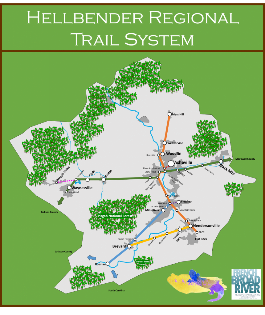
The current plan calls for connecting many of the planned regional greenways, most of which are underway in some form as independent projects. Thus the plan benefits from many projects already built or in various stages of planning and funding. The current Hellbender map also includes many missing links that have not yet been planned on the ground, which is why the published map does not show exact routes. The proposed map looks like this:
Can you imagine that future? Picture this:
- Leave on a bike tour from Arden and stay in Rosman one night before heading deep into the forest to fly fish, without needing a car.
- Live in a neighborhood like Bent Creek and ride with your family into Asheville in less than 30 minutes on protected lanes, with no cars, very few red lights and no issues finding parking.
- Live in Horseshoe and work in Hendersonville without driving or paying to park a car.
- Ride from Asheville through the Swannanoa Valley to Old Fort to join the Fonta Flora trail and vice versa. Without riding on any part of Highway 70.
- Connect any of these communities without using a car, for any reason you can think up: Canton, Candler, West Asheville, Asheville, Woodfin, Weaverville, Mars Hill, Oteen, Swannanoa, Black Mountain, Ridgecrest, Fletcher, Bent Creek, Mills River, Horseshoe, Brevard, Hendersonville, Rosman.
Public Comment Guidance for your Hellbender Trail comments.
As an advocacy group, we are providing you with content that you can use to support this project. Simply incorporate one or two of the bullet points below into your public comment, but please write your comment in your own words.
The best public comments tell your own story, while incorporating a few key facts to support your position. Please borrow from this post as needed. Please consider sharing your comment with us; to do so, email it to ashevilleonbikes@gmail.com.
ECONOMIC BENEFITS.
The Hellbender Trail will create exceptional economic benefits for Western North Carolina. Even today, the economic impacts of cycling in Western North Carolina are very significant and, sadly, often ignored.
Consider that Western NC was one of the first MTB trail destinations on the East Coast to rise to worldwide attention after the birth of the sport. When front suspension for mountain bikes was invented, the first prototype Rock Shox forks were made in Fletcher, at the plant that we now know as Cane Creek. Beginning in the early 1990’s, riders began to flock to Tsali, to Pisgah, and to Bent Creek, places which still draw overnight trips dedicated to riding bikes. Major bicycle companies continue to pump their own ad dollars into our region, to film product launch videos here, continue to name bicycles after our trails, and every summer you can see bikes on the back of the cars on I-26, I-40, and the roads coming up from Atlanta. Each time you see those bikes, recognize that it means money for a town somewhere in Western NC.
What if we did something to encourage that pattern? What if a greenway and trail network connected many of the cities and trail systems? What kind of economic engine could that create? In the Outer Banks, North Carolina DOT invested $6.3 million to create a series of off-road bicycle paths in 2003, creating safe routes in place of previously dangerous shared-with-cars roads. Within 10 years, bicycle touring in the Outer Banks was generating $60 million in annual economic benefit.
Consider also that bicycle touring generated $43 million/year in economic impact in WNC, right now, as per the 2017 regional economic impact study. Have you ever stumbled across a tourism development ad for bicycle touring in WNC? Perhaps not, because this economic engine is also growing with very little outside assistance – imagine what bike touring could be if we built the Hellbender trail network and people from Charlotte could tour from Fonta Flora at Lake James all the way to Brevard, Rosman and beyond.
The Hellbender Trail will become a healthy economic engine that spreads tourist dollars across all the small towns that attract bicycle trips. This NCDOT study showed that a bike tourist spends an average of $190 every day that they’re in our area. Bicycle tourists would spend that money in each small town and stop along the way, unlike some of our current tourism, which is concentrated in a smaller number of cities.
In addition to having some of the best mountain biking trails in the country and a documented mtb economic impact of at least $38.2 million each year, Western NC is home to some of the leading bicycling industry manufacturing companies in the world. As bicycling grows, these companies grow, and they employ your neighbors, pumping revenue directly into your community in the form of wages, bonuses, and donations to local nonprofits. Visit some of these websites to learn more about the companies that your neighbors are already working for, located right here in WNC. Industry Nine, Kitsbow, Fox Suspension, Cane Creek, Rockgeist, Endless Cycles,The Flying Bike,Trail Dynamics, Outrider USA, Ohlins, Kolo Bike Park, Riveter, Bailey Mountain Bike Park, Bike Kanuga & Outfitter Bicycle Tours. Large and small, these businesses are making Western NC a better place to live.
HEALTH BENEFITS.
Regular access to active transportation options is a proven way to increase general population health at a regional level. The health benefits of regular bike rides, walks, and similar active transportation choices are huge in part because it is much easier to make a small change to your routine – like getting on a bike to get to work – when compared with the willpower it takes to create a special time in your personal calendar to “go exercise.”
One study of New York City’s spending on bike lanes and greenways found that, for every $1300 the City spent on bike lanes, City residents as a group lived one extra year at full health.
In areas where there are no trails, there are no trail users, and where there are no trail users, people are less healthy. Let’s get healthy by putting a greenway out your back door, so to speak.
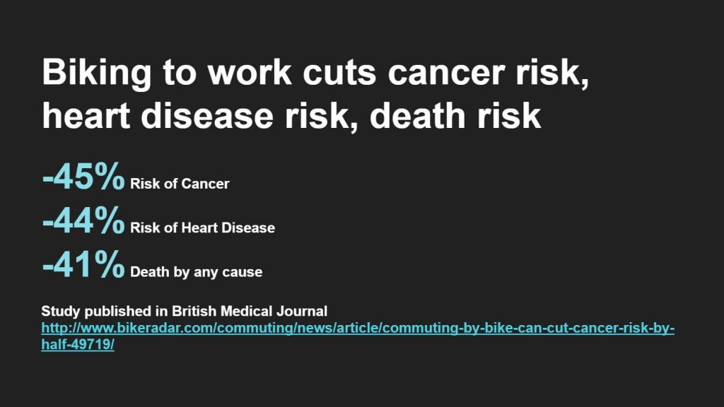
Link to article about the British Medical Journal study.
Picture this:
- After finding the Hellbender Network a convenient and safe place ride, you start riding a little everyday. At your next wellness appointment, your doctor takes you off a statin drug because, “You don’t need it anymore.”
- You live near the trail in Brevard and start using it to go downtown and to ride to the Davidson River in Pisgah. It’s just something you like doing, and it becomes a habit you keep all through your 50’s. Years later, you realize that although many of your family members have been treated for forms of cancer, you’re happy, healthy, and have not had cancer.
- Your best friend has always struggled with depression and serious mood swings. Their doctor suggests bike riding as a mental health support, and, even though they always thought of biking as a sport for people in tight clothes, they started riding. Your best friend finds the rides to be easy, safe, and mentally soothing. Since hitting the Hellbender, you see that they are a little happier everyday. Study.
The Dogwood Health Trust should take notice of this plan. Just as the FBRMPO is an appropriate planning partner, the Dogwood Health Trust could have an important role to play, given their substantial endowment and their mandate to spend each year improving the health of Western North Carolina citizens.
SAFETY BENEFITS.
Building the Hellbender trail means increased safety for all road users, because it will divert some walking and biking to the new network, reducing conflict on key road corridors. Consider this graph from the FBRMPO, which shows how dramatically bike and pedestrian collisions are rising in Western NC:
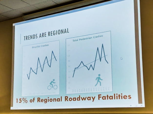
This image is from a presentation given by the FBRMPO in 2019 and this chart shows the increasing percentage based bike/ped fatalities of overall roadway fatalities from the last several years. The chart and trendline are for the entire region. As non-car users increase, if we do not create safer infrastructure (like the Hellbender), we will be faced with inevitable increases in bicycle and pedestrian crashes.
MOBILITY BENEFITS.
Just as some sections of the Blue Ridge Parkway carry local traffic, some sections of the Hellbender Trail will be put to use by locals who use it to replace a car trip. This is a good thing. Though many will be taken with the economic benefits, the tourism, and the freedom that comes from riding the Hellbender, a regional trail system also means mobility and active transportation that is available to all people, for any purpose.
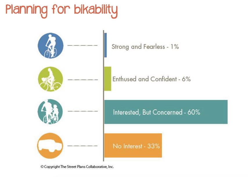
Not only will a regional trail system increase bicycle use, it will also concentrate bicycles onto dedicated facilities thus reducing motorist and bicycle conflicts on our roads. Even the motorists who never use the trail system benefit from the trail network. More people riding bicycles but fewer bicycles using roads without facilities is a winning future for all road users. Because of the user conflict and the palpable danger of riding a bicycle on the road in Western NC, we are missing many riders who are interested in riding a bike but concerned:
The future Hominy Creek Greenway provides an excellent example of a mobility benefit. That particular greenway plan is a small part of the Hellbender network as currently envisioned. That section of Greenway also connects part of Candler, part of Sardis Road, to the RADTIP, and thus downtown Asheville. Once built, someone living in an apartment adjacent to Hominy Creek can commute to downtown in about 20 minutes with an ebike, with almost zero red lights and no cars; on a regular bike, perhaps 30 minutes. Once downtown, they park for free and can easily avoid traffic congestion. Many will choose that commute when compared to the expense of driving and paying to park a car.
And owning a car is expensive. Even a modest 2015 Hyundai Sonata, as one example, costs $26,853 over five years to own and operate, not counting parking. What type of car do you drive? Are you staying late at work to earn enough just to pay the bills, including the car bill? Some of you are. What if you didn’t have to do that because you lived somewhere that offered you more than one transportation option?
For some, they simply cannot afford the car. For those workers making less than $40,000/year, car ownership is a huge burden on their cost of living, and yet in Western North Carolina we’ve made it a requirement. “Must have reliable transportation” is in a help wanted ad somewhere near you, running right now. Think about what that means in a region known for low wages.
What if we built something else, prioritizing people first, and parts of that network were used so that people could get to work? Personal mobility affects all of us – the rich, the poor, the young, the old. The Hellbender Trail network is a step in the right direction.
ENVIRONMENTAL BENEFITS.
With each transportation project in Western NC, we are choosing more asthma or less; more lung infection or less; longer life or shorter life; cleaner water or dirtier water. And more Hellbender salamanders, or fewer, up to the point where we find another treasured species extinct.
It is true that we have made dramatic improvements in our air quality during the last decade, with the largest changes directly tied to the closure or cleanup of coal-fired power plants in the surrounding states, as well as the closure of the Asheville coal-fired power plant. With these large single-source polluters cleaned up, where is our remaining pollution coming from?
Much of it comes from cars. We can no longer turn a blind eye to trips made in an automobile, which represent one of our region’s largest sources of Nitrous Oxide, Ground Level Ozone, and small particulate matter pollution. Those trips are measured as “Vehicle Miles Traveled” or “VMT.” The NC Department of Environmental Quality and NCDOT both specifically endorse the goal of reducing vehicle miles traveled (VMT) in order to create a cleaner, healthier environment. NCDOT Study and VMT Reduction Toolkit.
These improvements in measured pollution have a direct impact on how long we live, what diseases we face as we age, and how often we get sick. Reductions in pollution have an even stronger effect on all the plants and animals in the region, in part because plants and animals lack the ability to easily move around or go indoors when pollution is at its worst.
These environmental benefits are part of the reason this trail network is named after the Hellbender salamander, a species that depends on clean water. The Hellbender is in decline nationwide because we have degraded its habitat to the point that it has very few places left where it can survive. By helping reduce VMT, the Hellbender trail is good for the Hellbender – and for humans.
The Land of Sky Regional Council, of which the FBRMPO is a part, explicitly recognizes this connection and endorses the need to clean up our air.
Case Studies from similar trail systems in the U.S.
Centennial Trail Study
The Centennial Trail in Washington State provides an excellent example of a trail network that benefits multiple counties. To see the annual economic effect per county, click here, then go to page 13 and read from there.
Katy Trail Study
The Katy trail in Missouri is a 240 mile long trail that connects many small towns. It draws more than 400,000 visitors a year to the region. Page 38 breaks out the spending that results, from locals, non-locals, and overnight spending.
Great Allegheny Passage (GAP) Trail Study
The GAP Trail in Maryland and Pennsylvania is a 150 miles trail system with many small towns along the way. Well studied, the 2015 economic data showed that the trail had a direct impact on businesses along the route. “40% of the businesses planned to expand and of those reported to expand 67% attributed their expansion to the impact from the trail.”
Links to current FBRMPO planning documents for the Hellbender Regional Trail System:
Public comments open until August 21, 2020:
https://storymaps.arcgis.com/stories/2516fc1870db47cb8e3c7aa36dbed751
More project information:
http://frenchbroadrivermpo.org/multimodal/
Remember, the best public comments are written in your own words and tell a little of your story, combined with other facts about the project. Please borrow from this post as needed.
Public comment deadline August 21, 2020. Please consider sharing your comment with us; to do so, email it to ashevilleonbikes@gmail.com.