Today we are publishing our map for a connected network of biking, walking, ebiking paths that we would like to see built in Asheville. Internally, we’ve often referred to this map as “the Circulator.”
At its core, this map is one idea: We should plan for and build a connected network for biking and walking, routes that connect people to places without requiring the use of car.
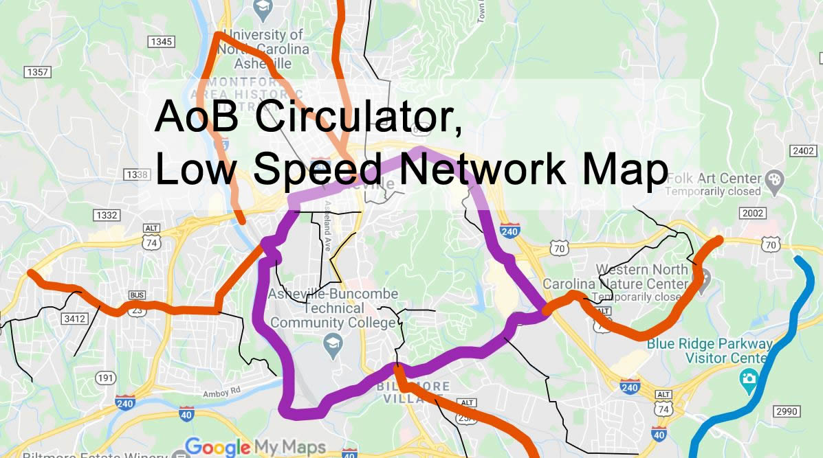
Black lines are low speed play streets. This network could work very similarly to the one in Oakland, which required only that the City designate the list of streets to be treated as slow streets. The enforcement and signage on these streets is put up and maintained by neighbors on the street.
Red and Purple are separated infrastructure on existing streets. Purple is the circulator, a mostly flat route that flows people to and from their destinations without requiring them to use a car.
Some of the lines on this map include existing bike lanes, existing greenways, or planned greenways. Our current City and County plans (AIM plan, Greenway plans) do not go far enough and we want to see a network built, not individual projects that do not connect to each other.
On all these streets cars continue to come and go, but portions of the right of way are altered to make safe paths for other users.
What streets should be added to this map? What streets should be removed? We welcome your comments.
If you want to compare maps and plans, here are the plans and maps that currently exist for either Asheville of Buncombe County.
The bicycle suitability road map (you must add the layer to this healthy living map): https://healthylivingmap.buncombecounty.org/
The Buncombe County Greenways master plan map: https://www.buncombecounty.org/common/parks/documents/greenways-master-plan/maps/full-county-overview.pdf
The 2008 Comprehensive Bicycle Plan https://drive.google.com/file/d/10Of4v6p5KiApAKj4rVQ5Ci2n_nQ1lAcm/view
The 2016 Asheville in Motion Plan https://drive.google.com/file/d/1-CWm7GvxcCDu6UORlniaknhWFDHdloCy/view
The 2005 City of Asheville Pedestian Plan https://drive.google.com/file/d/1KrVKssd7bZaoKeVKe5N5KpDFnto8aUJa/view
as a life log bike activist…i would love to be able to add suggestions to this map, but somehow…the map is not inter- active enough to do so….would it be possible to see smaller sections magnified so that we can all make better suggestions in what is needed for improvements?
Denise,
Thank you for commenting! You should be able to zoom in to see detail using the map embedded in this page. You can also download the .kml file for this map and play with it on Google Earth of the mapping software of your choice: https://drive.google.com/open?id=1mtgLtXVcv-0RGYgcuUL3zSzIH8x3F1ga
A safe way through Asheville by bike, being able to transition from the ride to the city without getting in a car would add so much to our economy without sacrificing culture. In most other areas of growth, they tend to be mutually exclusive. Connecting business with trails and keeping bicyclists safe at the same time seems like an obvious benefit to the triple bottom line. I’m can’t wrap my head around why CoA hasn’t moved forward on this yet. The streets can handle a lot more bikes than cars if even for the economic benefits alone. Then there is the maintenance of Ashevilles history as a place of health and wellness, R&R. Encouraging our guests and visitors to get outside is why they come here in the first place.