
On Tuesday, Dec. 4 from 4:00 – 8:00 pm at the Renaissance Asheville Hotel (31 Woodfin St 28801), North Carolina Department of Transportation hosts public comment on the I-26 Connect project.
Download a printable pdf of this blog post.
When the time comes to email your comments to NCDOT, please be sure to cc AoB at ashevilleonbikes@gmail.com.
Asheville on Bikes has reviewed NCDOT’s I-26 Connector plan and has compiled a list of recommendations to advance bicycle and pedestrian facilities. AoB recognizes that this project will have major negative impacts on our community but we acknowledge that the project is inevitable and, therefore, seek to maximize active transportation facilities and connectivity.
Asheville on Bikes is informed by National Association of City Transportation Officials’ (NACTO) “Designing for All Ages and Abilities” report, and critiques NCDOT’s I-26 Connector project through the lens of creating active transportation facilities that are: safe, comfortable, and equitable.
Asheville on Bikes encourages our members and supporters to review our list of recommendations and consider them as they participate in NCDOT’s upcoming public hearing.
AoB’s General Recommendations:
- Incorporate NACTO design standards and best practices to ensure safe intersection designs, especially at key intersections at proposed greenways and MUPs, and in busy pedestrian areas.
- Incorporate standardized pavement markings on all greenways and MUPs throughout the project to assure safety and minimize user conflicts.
- Incorporate NACTO standards in all contract terms for design and construction of the project. While NCDOT and the City of Asheville have not yet adopted NACTO design standards as official policy, NACTO standards do not conflict with the American Association of State Highway Transportation Officials (AASHTO) standards. Rather, they complement and inform AASHTO standards. Incorporating NACTO standards allows designers to create the safest and most reliable intersections in dense and busy urban settings like Asheville.
- There is speculation throughout the community that some of the active transportation facilities indicated on the maps are intended as opportunities for future inclusion after the project is built. If true, this is unacceptable. The project area has some of the highest bicycle and pedestrian counts in the community, and the need for improved multimodal infrastructure is immediate and critical, especially in light of the vehicular traffic impact the project will cause. The proposed greenway and MUP facilities will immediately be some of the most heavily used in the community. Moreover, building these important facilities after initial construction will be significantly more difficult and expensive. It is imperative that all active transportation facilities be built in tandem with the I-26 connector project.
Questions we think you should ask at the 12/4 public hearing:
- Will you walk me through, using your map, how I can ride my bike with my 3rd grader following me on her bike, along Haywood Road, headed west, across the redesigned intersections that span I-240. I’d like to travel from Beacham’s Curve (near Hall Fletcher Elementary) which is near my house, to the area near the top of State Street and Haywood (Sunny Point restaurant). Please explain the conflict points with other road users that I will encounter along this stretch, including car speeds, so that I can explain them to my daughter.
- Because the state pays no property taxes as a private landowner would, and this project increases the acreage owned by the state within City limits, this project is reducing the tax base of the City of Asheville. If it were built today, how many acres would be removed from the property tax roll, in total, based on these designs, for all three sections of the project? What is the amount, in today’s dollars, of the property taxes that are owed each year on that acreage?
- If the “caged” infrastructure remains on the northern section of the Jeff Bowen bridge, how does this project improve the mobility of the Hillcrest community? What’s the rationale for only building a multi-use path on the southern side of the Bowen bridge?
- Smith Mill Creek & West Asheville greenways merge and then cross intersections near Hazel Mill Rd, west of the Wally Bowen bridge. These crossings have been identified as a high conflict area by Asheville on Bikes. Where have you seen this type of conflict on other projects and what measures has NCDOT taken to improve safety of bicyclists and pedestrians? What are some treatment options? (Refer to F)
- As currently designed can you show me how a Burton Street resident would connect to Smith Mill Creek greenway? Does this connection seem adequate to you? Does this seem like an efficient connection? Might there be an alternative connection? (G)
- This project includes many miles of multi-use paths and other necessary bike and pedestrian features. Will those be built at the same time as the changes to the roads? What needs to occur for those features to be built?
- As currently designed, how would people living on Hubbard St access the French Broad greenway from their neighborhood? Does this connection seem adequate to you? Does this seem like an efficient connection? Might there be an alternative connection?
- The “Schwartz Memorandum FIES Technical Addendum” was included in NCDOT’s EIS as an addendum. The report was carefully researched and it outlines many changes that make life better for Asheville citizens. What is NCDOT’s legal obligation to include the recommendations in the Schwartz report? What can I do to make it likely that you will incorporate those recommendations in the project?
- NCDOT made many changes to the Brevard – Amboy design pdf compared to previous designs, including dead ending Virginia Avenue and adding a frontage road south of I-26, above the French Broad River Campground. Please walk me through this new design for this part of the project.
To view high resolution maps, visit the NCDOT project site to download the pdf files. By viewing the pdf, you can zoom in and move around each section of the project. Our excerpts are based on those pdf files as they exist on 12/1/2018.
Specific Design Comments (all referenced by letter in the map excerpts):
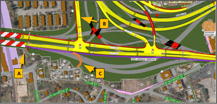
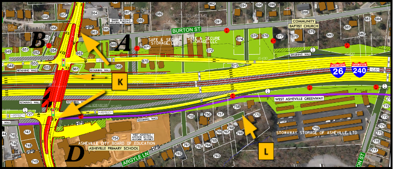
![]() The current caged walkway connecting the Hillcrest neighborhood across Patton Avenue is not suitable for future use, especially given the presence of the new greenway. It is narrow, caged, with steep steps, and not functional for bicycle use. A new structure should be included that features ramps and not steps, is not caged, and is wide enough for bicycle users to pass each other (at least 8’). It should provide a bikeable merge onto the greenway.
The current caged walkway connecting the Hillcrest neighborhood across Patton Avenue is not suitable for future use, especially given the presence of the new greenway. It is narrow, caged, with steep steps, and not functional for bicycle use. A new structure should be included that features ramps and not steps, is not caged, and is wide enough for bicycle users to pass each other (at least 8’). It should provide a bikeable merge onto the greenway.
![]() Arlington Street should be designed for vehicular traffic @ 25 mph and should include traditional bicycle lanes of 5’ on each side of the travel lanes. This will be a heavily-used bicycle connector for the Hillcrest neighborhood and for all of the Montford neighborhoods via Hill St. and Courtland St.
Arlington Street should be designed for vehicular traffic @ 25 mph and should include traditional bicycle lanes of 5’ on each side of the travel lanes. This will be a heavily-used bicycle connector for the Hillcrest neighborhood and for all of the Montford neighborhoods via Hill St. and Courtland St.
![]() A neighborhood connector path (8’ wide, simple asphalt) should be provided, connecting the greenway to Club St. This will ensure that cyclists and pedestrians are not forced to travel all the way to Clingman Ave. to access the Chicken Hill neighborhoods and the River Arts District. Many bike/ped users of the greenway travelling across the Bowen Bridges from the west will have the River Arts District as their destination.
A neighborhood connector path (8’ wide, simple asphalt) should be provided, connecting the greenway to Club St. This will ensure that cyclists and pedestrians are not forced to travel all the way to Clingman Ave. to access the Chicken Hill neighborhoods and the River Arts District. Many bike/ped users of the greenway travelling across the Bowen Bridges from the west will have the River Arts District as their destination.
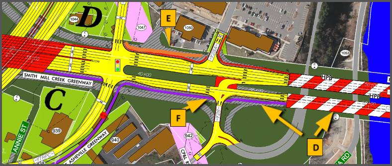
![]() The portion of the West Asheville Greenway that runs from its merge with Smith Mill Creek Greenway to Clingman Avenue, given number of people living along each greenway and their desire to travel to and from downtown, or to enjoy the view overlooking the river, could well be the most heavily used section of greenway anywhere in the community and perhaps in the state of North Carolina. AASHTO standards provide guidance for greenway width specifications based on use levels, and accordingly this section of greenway should be designed at 16’ wide. All greenways and MUPs throughout the project should include standardized pavement markings to assure safety and minimize user conflicts.
The portion of the West Asheville Greenway that runs from its merge with Smith Mill Creek Greenway to Clingman Avenue, given number of people living along each greenway and their desire to travel to and from downtown, or to enjoy the view overlooking the river, could well be the most heavily used section of greenway anywhere in the community and perhaps in the state of North Carolina. AASHTO standards provide guidance for greenway width specifications based on use levels, and accordingly this section of greenway should be designed at 16’ wide. All greenways and MUPs throughout the project should include standardized pavement markings to assure safety and minimize user conflicts.
![]() This facility will be subject to heavy usage from cyclists and pedestrians accessing Westgate Shopping Center. Instead of a 6’-wide standard sidewalk in this location, there should be a 10’-wide marked MUP to accommodate the mix of cyclists and pedestrians.
This facility will be subject to heavy usage from cyclists and pedestrians accessing Westgate Shopping Center. Instead of a 6’-wide standard sidewalk in this location, there should be a 10’-wide marked MUP to accommodate the mix of cyclists and pedestrians.
![]() This will be a very busy intersection for vehicle travel. Because the intersection will not be signalized and will be very active, automobile traffic will typically be moving rapidly between Patton Ave. and Hazel Mill Rd. The greenway will be very busy here, and potential for safety problems will be very high, especially in the evenings and other times of low visibility. Traffic calming and other measures should be deployed to ensure safe crossing of Hazel Mill Rd. for greenway users. Additionally, Hazel Mill Rd. as it leaves Patton will be a very popular route for bicycles and pedestrians to access the River Arts District on the west side of the river. The section of Hazel Mill to be rebuilt here by DOT should incorporate sidewalk and bicycle design features.
This will be a very busy intersection for vehicle travel. Because the intersection will not be signalized and will be very active, automobile traffic will typically be moving rapidly between Patton Ave. and Hazel Mill Rd. The greenway will be very busy here, and potential for safety problems will be very high, especially in the evenings and other times of low visibility. Traffic calming and other measures should be deployed to ensure safe crossing of Hazel Mill Rd. for greenway users. Additionally, Hazel Mill Rd. as it leaves Patton will be a very popular route for bicycles and pedestrians to access the River Arts District on the west side of the river. The section of Hazel Mill to be rebuilt here by DOT should incorporate sidewalk and bicycle design features.
![]() A neighborhood connector MUP (8’ wide, simple asphalt) should be provided to connect the Burton Street neighborhood to the Smith Mill Creek Greenway. Otherwise, cyclists and pedestrians in those neighborhoods could be forced to travel much greater distances uphill and westward for access.
A neighborhood connector MUP (8’ wide, simple asphalt) should be provided to connect the Burton Street neighborhood to the Smith Mill Creek Greenway. Otherwise, cyclists and pedestrians in those neighborhoods could be forced to travel much greater distances uphill and westward for access.
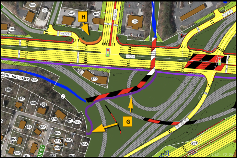
![]() Residential areas branching from the Hazel Mill Rd. corridor are very populous and growing. Hazel Mill Rd. will be a busy and popular route for those seeking access to Smith Mill Creek Greenway and points beyond. The Hazel Mill / Patton intersection here should be connected to the Regent Park/Patton intersection by a 10’ wide properly marked MUP to provide adequate safe connection. A simple 6’ sidewalk here is not suitable for cyclists and pedestrians to mix, especially at the edge of Patton Ave.
Residential areas branching from the Hazel Mill Rd. corridor are very populous and growing. Hazel Mill Rd. will be a busy and popular route for those seeking access to Smith Mill Creek Greenway and points beyond. The Hazel Mill / Patton intersection here should be connected to the Regent Park/Patton intersection by a 10’ wide properly marked MUP to provide adequate safe connection. A simple 6’ sidewalk here is not suitable for cyclists and pedestrians to mix, especially at the edge of Patton Ave.
![]() Neighborhood MUP connectors (8’ wide, simple asphalt) should be provided to allow the extensive neighborhoods of East West Asheville to connect to the West Asheville greenway via Dellwood, Vandalia, and Richland Streets. This will significantly reduce the number of cyclists that would otherwise mix in at the Haywood Rd. and Hazel Mill Rd. access sites.
Neighborhood MUP connectors (8’ wide, simple asphalt) should be provided to allow the extensive neighborhoods of East West Asheville to connect to the West Asheville greenway via Dellwood, Vandalia, and Richland Streets. This will significantly reduce the number of cyclists that would otherwise mix in at the Haywood Rd. and Hazel Mill Rd. access sites.
![]() The West Asheville Greenway between Haywood Rd. and the merge with the Smith Mill Creek Greenway is a primary connection between downtown and the River Arts District for a large population and will be very busy. Accordingly, per AASHTO guidance, it should be sufficiently wide (14’) and properly marked.
The West Asheville Greenway between Haywood Rd. and the merge with the Smith Mill Creek Greenway is a primary connection between downtown and the River Arts District for a large population and will be very busy. Accordingly, per AASHTO guidance, it should be sufficiently wide (14’) and properly marked.
![]() The Haywood Rd. bridge over I-26 and the intersection with the West Asheville Greenway will be a very busy area for cyclists given the populous neighborhoods and popular commercial areas that radiate from here and public school adjacent to the intersection. As currently depicted, the bridge and the approaches do not incorporate bicycle features or safe pedestrian facilities. The current design allows for increased automobile speeds compared to the immediately adjoining sections of Haywood Rd. Traffic calming features, narrower travel lanes, and traditional 5’ bike lanes should be incorporated on Haywood, as should NACTO-standard intersection treatments.
The Haywood Rd. bridge over I-26 and the intersection with the West Asheville Greenway will be a very busy area for cyclists given the populous neighborhoods and popular commercial areas that radiate from here and public school adjacent to the intersection. As currently depicted, the bridge and the approaches do not incorporate bicycle features or safe pedestrian facilities. The current design allows for increased automobile speeds compared to the immediately adjoining sections of Haywood Rd. Traffic calming features, narrower travel lanes, and traditional 5’ bike lanes should be incorporated on Haywood, as should NACTO-standard intersection treatments.
![]() A neighborhood connector MUP (8’ wide, simple asphalt) should be provided to connect Argyle Lane to the West Asheville Greenway.
A neighborhood connector MUP (8’ wide, simple asphalt) should be provided to connect Argyle Lane to the West Asheville Greenway.
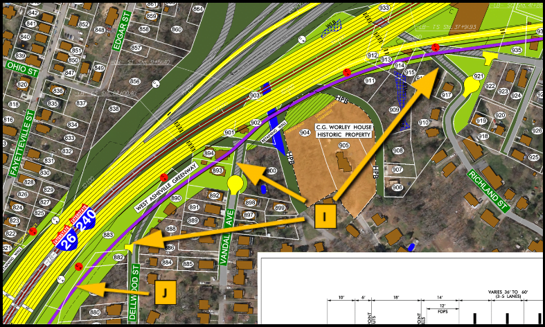
![]() In the proposed design, Hubbard Avenue in West Asheville would be significantly isolated and unconnected to Virginia Ave. and other possible connections to the Amboy Rd. MUP due largely to topography. An additional section of neighborhood connector MUP (8’ wide, simple asphalt) should be included. This will allow for neighborhoods beyond Hubbard to also connect efficiently to Hominy Creek, Carrier Park, and other areas.
In the proposed design, Hubbard Avenue in West Asheville would be significantly isolated and unconnected to Virginia Ave. and other possible connections to the Amboy Rd. MUP due largely to topography. An additional section of neighborhood connector MUP (8’ wide, simple asphalt) should be included. This will allow for neighborhoods beyond Hubbard to also connect efficiently to Hominy Creek, Carrier Park, and other areas.
![]() There should be a neighborhood connector MUP (8’ wide, simple asphalt) from Virginia Ave. to the Amboy Rd. MUP.
There should be a neighborhood connector MUP (8’ wide, simple asphalt) from Virginia Ave. to the Amboy Rd. MUP.
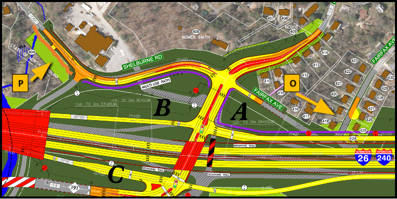
![]() There should be a neighborhood connector MUP (8’ wide, simple asphalt) connecting Fairfax Ave. to the Amboy Rd. MUP
There should be a neighborhood connector MUP (8’ wide, simple asphalt) connecting Fairfax Ave. to the Amboy Rd. MUP
![]() A section of standard MUP (10’ wide, marked), should be provided to extend the Amboy Rd. MUP to the trailhead of the City’s current Hominy Creek Greenway. Without this connection, cyclists and pedestrians would be forced out into this busy part of Shelburne Rd. due to the steep bank that exists there now between the roadways and the DOT-owned paved parking area.
A section of standard MUP (10’ wide, marked), should be provided to extend the Amboy Rd. MUP to the trailhead of the City’s current Hominy Creek Greenway. Without this connection, cyclists and pedestrians would be forced out into this busy part of Shelburne Rd. due to the steep bank that exists there now between the roadways and the DOT-owned paved parking area.
![]() The Riverside Drive MUP will provide a critical commuter route to connect with Broadway, UNC Asheville, and Woodfin areas where additional greenways and bike lanes are planned. A parallel greenway is planned by the City of Asheville to be located largely at the edge of the river. Because the greenway will accommodate a portion of the heavy use demand in the corridor, a 10’-wide MUP facility should suffice. Note that this MUP will be popular for faster-traveling bicycle commuters while the river-edge greenway will be popular for other slower-paced uses. Given the anticipated heavy-use in the corridor, both facilities are critically needed.
The Riverside Drive MUP will provide a critical commuter route to connect with Broadway, UNC Asheville, and Woodfin areas where additional greenways and bike lanes are planned. A parallel greenway is planned by the City of Asheville to be located largely at the edge of the river. Because the greenway will accommodate a portion of the heavy use demand in the corridor, a 10’-wide MUP facility should suffice. Note that this MUP will be popular for faster-traveling bicycle commuters while the river-edge greenway will be popular for other slower-paced uses. Given the anticipated heavy-use in the corridor, both facilities are critically needed.
I just thank AoB for working on this plan to make sure it suits pedestrians and bikers. Little of it do I understand, so I am grateful for YOU! I will be there tonight to stand beside you.
Mary Johnson
Thanks for posting these comments. It’d be worth seeing what the Sam Schwartz comments were as well, and why is it that NCDOT keeps ignoring the City’s consultants? It is worth combing through these drawings and asking important questions. Note at “H” above. Really let that intersection wash over you. Patton is TEN lanes wide. Under what possible scenario would we need an intersection with double turns into and out of that intersection? Where did those trip projects get created, in an area that is built out already? Also, NEPA requires minimizing impacts, and not doing things like culverting creeks.
It looks like they’re still doing it here, and there are other design options that minimize that creek impact (and could allow for a trail ‘underpass’ given the grade difference in this location. Additionally, the City’s greenway plan calls for opening up the creek at Riverside Cemetery and reconnecting the Riverside park and cemetery with the River. NCDOT neglects that with their work. NCDOT “says” that they are not modifying that area, yet, the plans clearly show that that area is modified, and they contradict/ignore/impact (their choice) the local plan.
Joe,
Thank you for this comment. We also have noticed the culvert and large retaining wall affecting Riverside Cemetery, but did not realize the City had a planning document calling for it to be daylighted again. That would be a nice connection for North Asheville. We also support a version of Patton that is smaller and more multi-modal in both directions, compared to what they are showing in these designs.