If you want a connection from Biltmore Village and downtown for bikes and pedestrians this is your moment to shine! The City of Asheville has published a survey you need to take and AoB is here to help.
2 Action Items:
- Take the survey and emphasize bike and pedestrian facilities when you answer each question.
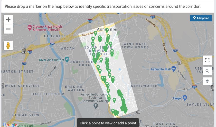
- In the map section of the survey, drop at least 7 pins, with text descriptions, on their map (you can drop more). We have suggestions listed below.
Your support is critical to advance bicycle and pedestrian facilities between Downtown and Biltmore Village.
Why this survey matters
It’s essential to amplify support for bicycle and pedestrian investment along this corridor, which is controlled by NCDOT. In order for our transportation planning system to decide to make a change, we must present evidence that change is needed, that it can succeed, and that we are paying attention. To this end, AoB provides you with input guidance; please use it and share it.
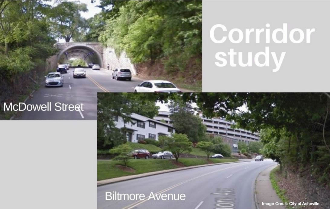
Biltmore and McDowell should serve different purposes
Biltmore and McDowell should serve different purposes in establishing an active transportation network. Biltmore Ave, if made safe, is the preferred north south bicycle pedestrian connection from downtown to Biltmore Village and is a good candidate for a road diet and complete street treatments. Even with the current dangerous conditions it is used as a cycling route by people with limited transportation options.
In contrast, McDowell can handle extra vehicular traffic so long as bicycle pedestrian crossing movements are well protected at intersections, allowing easy filtering of bicycles and pedestrians who are moving to and from the Southside, East End , and French Broad neighborhoods as well as the River Arts District. Therefore, you are encouraged to prioritize bicycle and pedestrian facilities on Steps 3 & 4 of the survey.

Unlock hidden demand for walking, biking, and ebiking
- East End / Valley St = 1968 residents
- Downtown (Darn) = 3424 residents
- South French Broad= 2149 residents
- Kenilworth = 3902 residents
- Saint Dunstans = 51 homes, 146 Condos (508 residents)
- White Fawn = 55 homes, 97 Apartments
- Reed St / London Rd = 230 homes
- Oakley = 6238 residents
In Buncombe County we average 2 cars per residence. If we assume 1 car per resident and, where we only know the number of homes, 2 cars per home, we have at least 19,347 cars in these adjacent neighborhoods.
Because these neighborhoods do not have safe active transportation options, most residents drive everywhere in those cars. Consider the foolishness of planning a City where nearly all Kenilworth residents are asked to move a car ½ mile to downtown and back. A road diet for Biltmore Ave enables people to diversify their habits of transportation. We can make changes that unlock the latent demand, currently unmeasured, for biking and walking to and from these areas. Let’s reduce congestion by reducing car trips.
Guide to the survey with examples
The Biltmore and McDowell St Corridor Survey is a 7 step process. AoB’s survey guide directs people to respond to a few questions in very specific ways in order to amplify the need for robust active transportation investment in the corridor. Follow AoB’s guidance but you’re also encouraged to share your own perspectives, especially in Step 7.
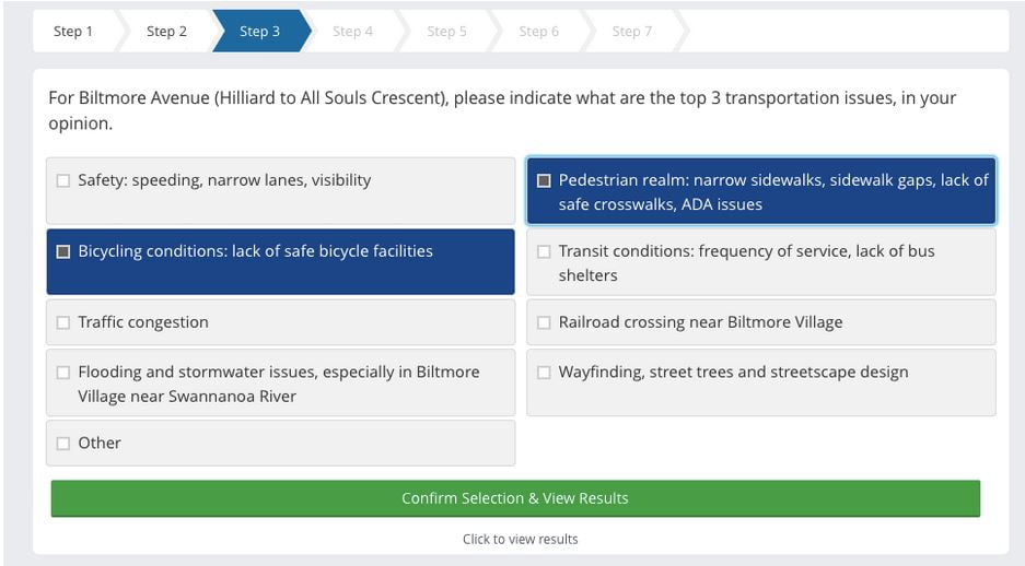
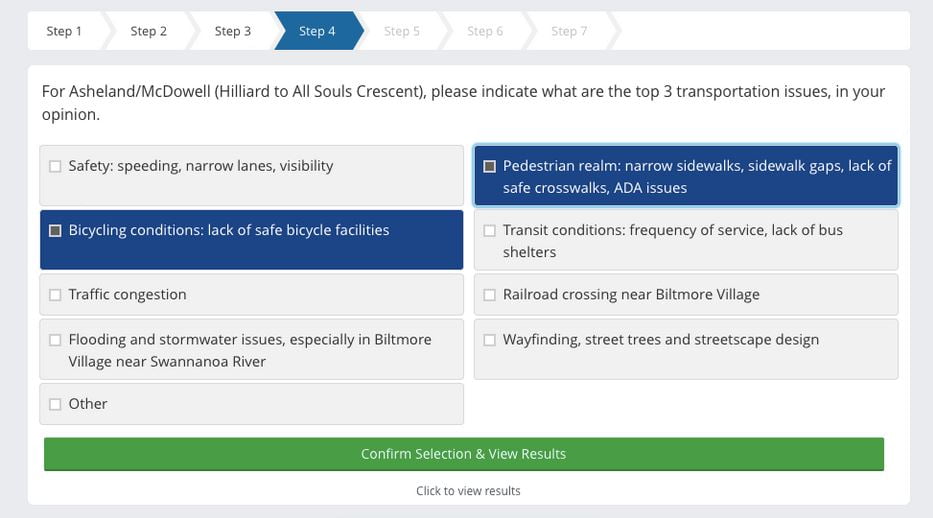
Survey Steps 3 & 4:
Be sure to prioritize bicycle and pedestrian issues as the top three issues. Avoid selecting congestion because, historically, NCDOT’s only solution to congestion is road widening for automobiles.
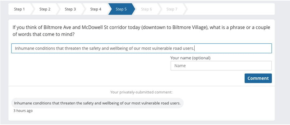
Survey Step 5:
Call out the existing conditions for what they are and use the language below so that NCDOT and City of Asheville have to face that the built environment puts people’s well being at risk. Copy and past this statement into the text box:
“Inhumane conditions that threaten the safety and wellbeing of our most vulnerable road users.”
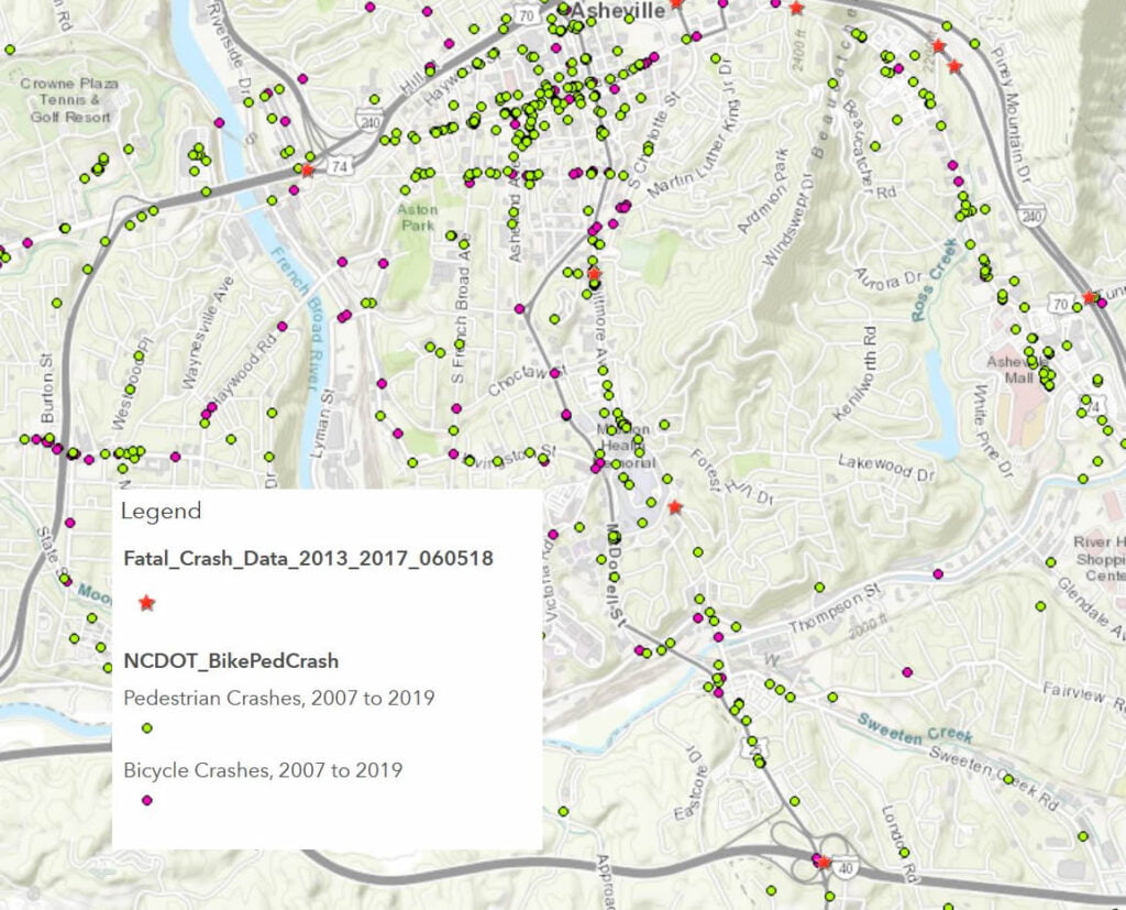
Why inhumane? Because these roads are deadly to all users and cannot be safely used with or without a car. Here’s a map of fatalities from all collisions + bicycle and pedestrian injuries that generated police reports, from just a few recent years:
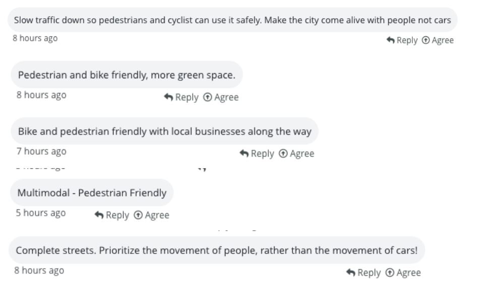
Survey Step 6:
Up vote the comments, please amplify the comments that support bicycle and pedestrian investment by selecting the “agree” option.
Examples of types of comments to amplify:
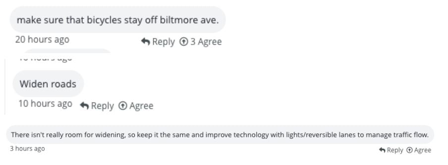
Examples of comments that we disagree with:
Survey Step 7:
AoB has prioritized 7 pins and provided corresponding copy for you to copy and paste into each textbox. For this survey, AoB opted to focus on critical intersections (but will publish on recommended facilities in upcoming posts) because The National Association of City Transportation Organizations (NACTO) emphasizes the importance of thoughtful intersection design.
Drop pins at the following intersection and past copy into the pin textbox.
Pin 1: Asheland Ave, Phifter St, & Southside
Phifer St across the Southside Ave is a high priority east west active transportation connection that will include future greenway connectivity therefore complete street treatments are essential.
Asheland from Patton Ave to Southside is experiencing mixed use development and therefore a complete street treatment is essential to public safety and mobility.
Pin 2: Biltmore Ave, Southside Ave, & S. Charlotte St
Biltmore Ave & Southside Ave is a high priority east west connection that connects the East End Neighborhood to the South Slope, it will include future greenway connectivity, and this area is vibrant with pedestrians during baseball season. An improved complete street treatment is essential to public safety.
Pin 3: Biltmore Ave & Short Coxe
Short Coxe and Biltmore Ave is a transit stop that lacks pedestrian and bicycle facilities. As Biltmore adopts complete street designs this intersection should be improved. This intersection has a high rate of pedestrian vehicular conflict, reflected in collision reports.
Pin 4: McDowell St & Choctaw St
Choctaw and the Nasty Brand alignment are future east west greenway connections which serve to connect French Broad Neighborhoods and the River Arts District to the hospital, Mountain Side Park and Beaucatcher Ridge.
Pin 5: Biltmore Ave & Hospital Dr to Victoria Rd & Livingston St
The current car-centric design of Victoria Rd and Hospital Dr does not allow for safe east-west connections by bicycle. These intersections are ripe for bicycle and motorist conflicts, nor do they match the intent of the proposed Livingston complete street treatment. Bicycles cannot trigger any of the lights, Hospital Dr is wide, and cars are fast moving. This corridor connects the Southside neighborhood to the hospital, to AB Tech, to the greenways in the River Arts District, as well as connecting Kenilworth to those same areas. This east-west flow of bicycle and pedestrian traffic needs to be encouraged and provided with safer streets.
Pin 6: Biltmore Ave & Forest Hill Dr
Forest Hill Dr connects the Kenilworth Neighborhood to downtown, Biltmore Village, the hospital, Asheville Highschool, and AB-Tech. This intersection should be improved to accommodate a variety of modes. A road diet with a center turn lane would make multiple dangerous turning motions more safe.
Pin 7: Biltmore Ave & Caledonia Rd
Caledonia connects the Kenilworth Neighborhood to Biltmore Village and future greenway systems along the French Broad and Swananoa Rivers therefore the intersection should be improved to accommodate a variety of modes. A road diet with a center turn lane would make multiple dangerous turning motions more safe.
Pin 8: Biltmore Ave & Meadow Rd
Biltmore & Meadow intersection are foundational to Asheville’s greenway network and the proposed Hellbender Regional Trail System as it connects East Asheville, to South Asheville, and North Asheville along the French Broad and Swannanoa Rivers.
Thank you! Go take that survey!
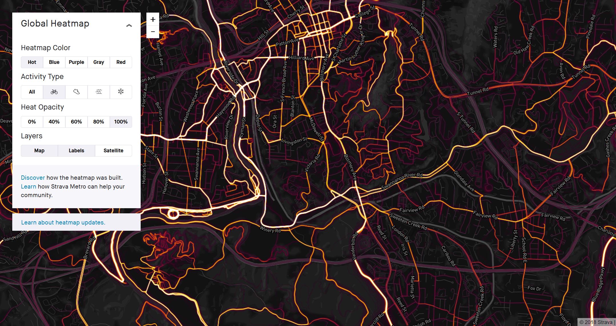
Map of bicycle usage from the Strava global heatmap. This map shows the clear preference for Biltmore, for cycling, as a necessary route between Biltmore Village and downtown: